


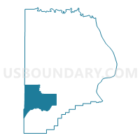
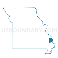
Whitewater Voting District, Cape Girardeau County, Missouri
About
Outline

Summary
| Unique Area Identifier | 607381 |
| Name | Whitewater Voting District |
| County | Cape Girardeau County |
| State | Missouri |
| Area (square miles) | 43.22 |
| Land Area (square miles) | 42.87 |
| Water Area (square miles) | 0.34 |
| % of Land Area | 99.21 |
| % of Water Area | 0.79 |
| Latitude of the Internal Point | 37.26864470 |
| Longtitude of the Internal Point | -89.80199670 |
Maps

Graphs
Select a template below for downloading or customizing gragh for Whitewater Voting District, Cape Girardeau County, Missouri


Neighbors
Neighoring Voting District (by Name) Neighboring Voting District on the Map
- Burfordville Voting District, Cape Girardeau County, MO
- Delta Out County Voting District, Cape Girardeau County, MO
- Drum-Dongola Voting District, Bollinger County, MO
- Gordonville Voting District, Cape Girardeau County, MO
- Marble Hill No. 2 Voting District, Bollinger County, MO
Top 10 Neighboring County Subdivision (by Population) Neighboring County Subdivision on the Map
- Lorance township, Bollinger County, MO (4,366)
- Hubble township, Cape Girardeau County, MO (1,861)
- Liberty township, Bollinger County, MO (1,371)
- Welch township, Cape Girardeau County, MO (1,231)
- Kinder township, Cape Girardeau County, MO (1,158)
- Liberty township, Cape Girardeau County, MO (439)
Top 10 Neighboring Place (by Population) Neighboring Place on the Map
Top 10 Neighboring Unified School District (by Population) Neighboring Unified School District on the Map
- Jackson R-II School District, MO (30,067)
- Woodland R-IV School District, MO (5,940)
- Advance R-IV School District, MO (3,021)
- Delta R-V School District, MO (2,142)
- Leopold R-III School District, MO (889)
Top 10 Neighboring State Legislative District Lower Chamber (by Population) Neighboring State Legislative District Lower Chamber on the Map
Top 10 Neighboring State Legislative District Upper Chamber (by Population) Neighboring State Legislative District Upper Chamber on the Map
Top 10 Neighboring 111th Congressional District (by Population) Neighboring 111th Congressional District on the Map
Top 10 Neighboring Census Tract (by Population) Neighboring Census Tract on the Map
- Census Tract 9502, Bollinger County, MO (4,609)
- Census Tract 8803, Cape Girardeau County, MO (4,387)
- Census Tract 9503, Bollinger County, MO (3,063)
Top 10 Neighboring 5-Digit ZIP Code Tabulation Area (by Population) Neighboring 5-Digit ZIP Code Tabulation Area on the Map
- 63701, MO (36,812)
- 63755, MO (24,006)
- 63764, MO (5,984)
- 63740, MO (5,339)
- 63730, MO (3,430)
- 63785, MO (1,000)
- 63760, MO (614)
- 63745, MO (66)